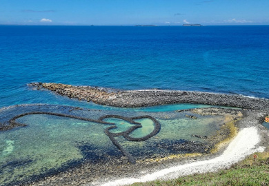
Taiwan is a country ideally set up for bike touring.
It’s incredibly bike-friendly, the people are fantastic, the convenience is second-to-none and the scenery is astonishingly varied. In the space of a single trip, you can ride rugged Pacific cliffs, alpine mountain highways, lush rice-paddy valleys and gentle coastal roads. Add in excellent food, hot springs, affordable accommodation and a unique blend of Han Chinese and Indigenous Taiwanese cultures, and it’s the complete package for an unforgettable cycling adventure.
Being a relatively small island, Taiwan can be crossed south-to-north in as little as a week, making it a very feasible bike touring destination.
While there’s the official Cycling Route 1 that loops around Taiwan’s coastline, I think there are better variations with less traffic and often more interesting scenery along the way.
Having lived in Taiwan and toured the country twice by bike, I’d like to share what I think is the most varied and rewarding alternative. This 9-day Taiwan cycling route covers approximately 750km from Kaohsiung to Taipei, taking in Kenting National Park, Taiwan’s spectacular Pacific Coast, the East Rift Valley, the Suhua Highway and Yangmingshan National Park. If you’re planning a Taiwan bike tour and looking for an alternative to Cycling Route 1, this itinerary combines quiet roads, mountain scenery, coastal riding and some of the very best cycling in Taiwan.
Taiwan Bike Tour at a Glance
Distance: ~750km
Duration: 9 days
Difficulty: Moderate
Best Time: March-April, October-November
Start & Finish: Kaohsiung / Taipei
Day 1: Kaohsiung to Kenting National Park
Seaside day to Taiwan’s prime beach resort
Distance: 89km
Elevation: ~525m
I chose Kaohsiung as my starting point, with the idea of finishing by Taipei 101 and the ease of onward logistics (flight back out etc). Plus, going anticlockwise, you get best access to and view of the coast than going the other way.
Kaohsiung is a lovely city, but cycling out of it is gritty, slow and unpleasant – especially heading south right through the main industrial and port area. Having had the “pleasure” of doing so once before, I opted to skip that part and catch a local 1-hour TRA train from Kaohsiung Main Station to the town of Fangliao. It’s the furthest south station you can take your bike before the railway crosses the coast, and you can usually just turn up before the train to get a bike ticket and just sit with your bike.
Fangliao. Less than 5 minutes from starting, I’m out of town and coasting along the seaside. The road quickly joins the main Highway 1 artery down to Kenting and the official Cycling Route 1. Marked by the blue line that’ll soon become all too familiar.
Day 1 offers a gentle introduction to Taiwan (that is, if you opted to skip outer Kaohsiung). The lovely coast stays on your right most of the way down, complemented by a mix of farmland & aboriginal villages and sandy beaches. Today is mainly flat and feels fast for the most part – with only a few rolling hills in the second half of the day.
When you can, I recommend mixing it up and veering off the main road onto quiet agricultural roads and village streets that often run parallel to the highway. You’ll notice these parts of Pingtung are particularly famous for their wax apples, dragon fruit and onions – depending on the season.


If you’re looking for a break, look no further than one of the most scenic convenience store stops I’ve ever come across. A few miles past Fangshan, look out for FamilyMart – right on the coast. Here you can enjoy refreshments right on the dark sand beach.
Not long after you’ll notice a tall bridge heading inland – that’s road 9, the main route to the east coast. Some cyclists will opt for this route, but I think you’d miss out by skipping Kenting National Park. So go straight and continue on south.
After a couple rolling hills I reach the town of Checheng. If time allows, veer off onto the quieter road of Hengchun Peninsula, with some lovely stretches especially around the sandy Baisha Beach. Where the peninsula rejoins the main route again you’ll notice a huge concrete structure that feels strangely out of place amid the otherwise beautiful scenery. If you’re wondering, that’s the very recently-decommissioned Maanshan Nuclear Power Plant.

More resorts start to show up on the approach to Kenting town – again with some pretty stretches of sandy beaches. Kenting itself is a good place to stop overnight with many options and a big night market – but to cut some distance from the next day I continue onwards to Taiwan’s southern tip.
At the tip of Cape Eluanbi is the Eluanbi Lighthouse, with some pretty cool views if you have time – despite needing to pay a small 60TWD entry fee and leave the bike behind. Around the corner, you’re now on the Pacific Coast and the free views are no less impressive. There’s a scattering of guesthouses along the route so a good place to rest for the evening with the wild cliffs right across the road.

Day 2: Kenting to Taitung
Big day of quiet jungle hills & epic Pacific Coast
Distance: 125km
Elevation: ~1,400m
With legs still full of energy, today was to mark the longest day of the tour at 125km and some decent climbing to go with it. Of course, you can also break this leg up into two days with a stop halfway in Daren or Dawu. Not that the day felt particularly grueling despite its distance – perhaps helped by the non-stop gorgeous scenery all along the way.
The beautifully quiet road out of Kenting briefly parts the sea for an undulating climb through aboriginal villages, farms and jungle. Troops of monkeys warn each other from treetops of my imminent arrival, and buffalos stare curiously at the sight of a red-faced foreigner. The road descends to what is probably my favourite bit of Taiwan’s Pacific coast roads due to it being the narrowest, quietest stretch right next to the shore – compared to that further up north. Absolutely gorgeous cycling.
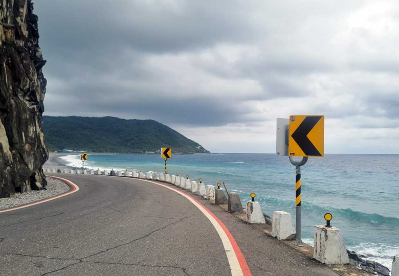

Snack up by the coast around the sleepy village of Xuhai, because the day’s main climb into the inland jungle awaits. You’ll go up the Shouka climb at 460m before descending back down to the ocean at Daren. By now, the intense noon sun has replaced the perfect morning temps – so I’m thankful there’s quite a bit of tree cover on the Shouka climb to offer some welcome shade.

A cycling rest stop marks the top of the climb where road 199 meets the old 9A road. The newly-built highway that runs in parallel to 9A took away most of the traffic from the picturesque 9A, so now it’s basically just a handful of mopeds and cyclists and maybe the postman that still use it. A stunning descent, with the azure waters of the Pacific growing in the distance.
Once back on the coast, it’s wise to find a random seaside village restaurant for some fresh catch. Talking of which: if you’re new to cycling in Taiwan, don’t be put off by how many of these places look from the outside – Taiwan is one of those countries where the most hole-in-the-wall looking places tend to churn out the best dishes.

The rest of the coastal route is majestic – a couple decent climbs taking you to gorgeous vantage points before fast descents back down to the almighty Pacific, where you’ll get close enough to get the wave spray on your face.
The city of Taitung gradually appears on the horizon and is the obvious destination for today’s ride. But I opt instead for the nearby Zhiben Hot Springs – slightly inland. The place kind of feels like you’ve travelled back in time a few decades. Old high-rise hotels from the 80s, overgrown with moss in a place that seems to have never recovered since being devastated by the 2009 Typhoon Morakot – when one of the bankside hotels literally collapsed into the river. I manage to land a bargain room with a large hot spring bath for 1000 TWD (~£20) which makes for a perfect ending to the long sweaty day.

Day 3: Taitung to Chishang
A day of variety: Sea, city, badlands, jungle and rice fields
Distance: 84km
Elevation: ~860m
The moment my feet touch the pedals, the clouds open up into a full deluge – as if the rain was waiting for my departure. I aquaplane down to nearby Taitung and join the Taitung Ocean Mountain Bikeway – a former railway – to the sea. Old train stops are still there – like ghosts, as if ready to resume service. There’s a cool abandoned sugar factory / train depot along the way, open to public (and a great refuge from the rain).
Taitung is probably Taiwan’s most laid-back city – there’s not much traffic, the locals seem extra relaxed and of course it gets the joys of being on the ocean. The cycleway leads you through to Taitung Seashore Park, where you can continue onto Taitung Forest Park. There’s a controlled entrance with a small 80 TWD entry fee, but absolutely worth it. The park boasts a decent choice of paved lanes going through gorgeous flora and wetlands full of birds. And it nicely connects to our onward country lanes heading north into Taiwan’s East Rift Valley.


The official ‘Cycling Route 1’ continues all the way along the route 9. But honestly, parallel routes are both quieter and far more interesting. So I turn onto provincial road 45. The long Liji Bridge across Beinan River marks the start of Liji Badland Geopark – known for its unusual rock formations. Here, route 197 carves its way up through jungly scenery with the backdrop of the big river valley down below. There’s hardly a sign of life up here until the road descends back down towards the East Rift Valley.
The sea of vividly green rice paddies marks today’s destination – the town of Chishang – famous for Taiwan’s finest rice and some of the most scenic country lanes on the island. Outside Chishang is a road known as “Mr Brown Avenue” – so called due to it reaching fame from iconic Mr Brown coffee adverts a few decades earlier. It’s particularly beautiful at golden hour, moments before the sun disappears above the towering Central Mountain Range that rises above the valley from the west.


Day 4: Into the Mountains
Climbing day up to Xiangyang
Distance: 78km
Elevation: ~1,800m
Today is a hardcore climbing day that goes into the mountains and right back into Chishang. So treat it as an optional “bonus” ride for those touring on road bikes and want to experience Taiwan’s mountains. Otherwise skip to day 5!
Two thirds of Taiwan is covered by mountains, so it would kind of be a shame not to experience them on a Taiwan cycling tour. I originally planned on the Taiwan KOM, known as the longest climb in the world. It’s easily Taiwan’s most famous mountain route called the Central Cross-Island Highway, which passes through the famous Taroko Gorge on the way to Wuling Pass. However still recovering from typhoons and earthquakes, the road was closed much of the time with timed entries – proving difficult to plan around especially as an engine-less cyclist.
So I found an alternative that proved to be just as gorgeous of an experience – the Southern Cross-Island Highway. Also ravaged by the landslides triggered by Typhoon Morakot, the highway took 15 years of fixing before mostly re-opening in 2022. The top section across to the west coast is still closed to cyclists (as of 2026) from Xiangyang upwards, so if you want to cross west you’ll need to hitch a ride.

I left my bike bags in Chishang and just rode as far as I was allowed on a bike, up to the hot springs of Xiangyang, up at 2,300m above sea level. The road starts with a gently, almost unnoticeable climb. As the wide river valley narrows into a stunning gorge, the gradient starts to pick up a bit. Shops along the way are very scarce, so be sure to top up on drinks and food every chance you get.


There’s an especially beautiful section where you can see where the road leads high on the other side of the gorge – separated by a series of tunnels. Some roadworks are still taking place here so be wary of timed entry delays.
The gradient picks up further as the pass separates from the river, and I really begin to struggle in the mid-day sun. Gradually the terrain opens up to some incredible views of Taiwan’s Central Mountain Range – and tea terraces begin to pop up on the roadside.


I enjoy an exhilarating descent back down to the Rift Valley, by the end of which I start to feel all the symptoms of heat exhaustion and have to settle in bed for a fun and wild night of fever, chills and intense sweating.
Day 5: Chishang to Guangfu – East Rift Valley
Criss-crossing tectonic plates
Distance: 78km
Elevation: ~525m
Today is a light ‘recovery’ day, a necessity after yesterday’s monster climb and heat exhaustion. It’s a gentle and flat ride further up the East Rift Valley through rice paddies and occasional towns.
Taiwan’s farm land is criss-crossed with access roads to farms as well as river flood banks. Most are paved, often in surprisingly good condition and tend to go in parallel to bigger roads. So remember to weave onto these when you can – no traffic, just fields, birds and the ocassional farmer – it’s good fun to ride!


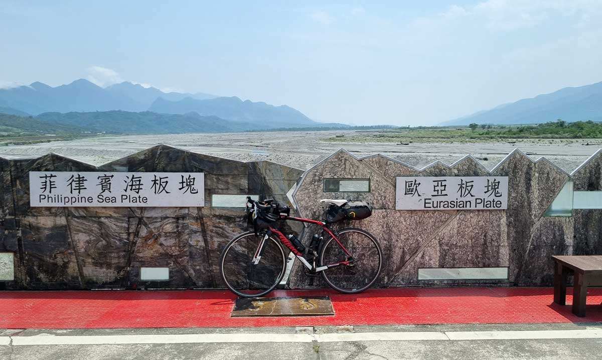
Approaching Yuli, take the long pedestrian bridge with a marker commemorating the boundary between the Eurasian Plate and the Philippines Sea Plate. It’s crazy to think that the other end of the Eurasian plate is all the way out in Iceland – but here we are. Yuli is a perfect lunch stop as it’s known for its Yuli noodles. I order a huge bowl, only to remember yesterday’s heat exhaustion has weirdly taken away all sense of taste except salt.
From Yuli to Guangfu, I honestly struggle to remember much along the way – the mind slow, body weak and the rice paddy valley scenery just sort of merged into one. The only desire at this point is to rest up and recover.
Only a brief chase by a couple local farm dogs awakes me from the stupor. In Guangfu, I find a place for the night and collapse into bed for recovery.
Day 6: Guangfu to Yilan – Suhua Highway
Gorgeous coastal climbs, whisky & hot springs
Distance: 76km
Elevation: ~750xm
Relatively well-rested, I make my way to the local Guangfu train station. From here, I plan to hop the remaining bit of Taiwan’s East Rift Valley to Hualien (Taiwan’s main hub on the East Coast), then change trains to Nan’ao.
Reason being is the abundance of long tunnels in this section that are busy with trucks and often lacking hard shoulders to keep a safe distance. It’s under an hour from Guangfu to Hualien, then another hour to Nan’ao with a bit of time in between for a brief mini-tour around Hualien. There’s also a good chance you’ll come across other bike tourers here to share your experiences with.


After the very scenic train ride to Nan’ao, I disembark in the sleepy Nan’ao and join Taiwan’s famous Suhua Highway. What was once a dizzyingly narrow and very dangerous military route through the East Coast is now the main artery carrying quite a bit of traffic including many trucks carrying gravel. Skipping the Hualien to Nan’ao section means skipping all but one of the long unpleasant tunnels lacking hard shoulders.
The first climb to the only big tunnel sets off pretty much immediately, going up steadily to 300m. Near the tunnel, a helpful local driver decides to help by “escorting” me through the tunnel, protecting me from potentially close and nasty overtakes through it. Legend.
The scenery that opens up after the tunnel on the descent is some of the most stunning on the tour so far – the mountains rising sharply right out of the azure-tinted waters of Dongao Bay. And that’s despite the fairly heavy rain at this point – I can only imagine what it looks like in finer weather!


The main road descends to Dong’ao – a chance to replenish before the main course climb of the day. The good news is – from here we join the old and very scenic Suhua Highway while all the traffic continues onto a newer road with a very long tunnel. All that’s left is the rare moped and some fellow cyclists. The old 9A road winds its way up the stunning coastline and despite the weather, makes for one of the most enjoyable and scenic climbs I’ve ever done. Neither is it very steep – a steady incline to 400m – then an epic descent down to the fishing town of Su’ao.
Here I follow a mix of the main designated Route 1 towards Yilan along the coast and whenever possible, smaller farm and seaside roads that often run in parallel. It’s now entirely flat but also quite urban.
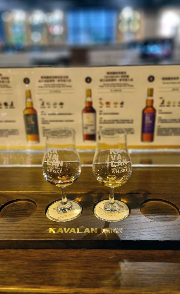
It’s now flat but mostly urban, and the next real point of interest a slight detour inland to Taiwan’s most famous Whisky Distillery – Kavalan. There’s a small entry fee but some of that goes towards a discount on whisky tasting. As it turns out, the higher end of Kavalan’s range is surprisingly smooth and enjoyable. Apparently the mountain-filtered waters of the nearby Lanyang River are that special. Marketing gimmick or not, I struggle to force myself to leave before the dark sets in.

By the way, if you’re not into whisky but love a craft beer, there’s a nice brewery and bar just down the road from Kavalan also making the best of the special water – Jim & Dad’s Brewing Company.
As the evening sets in, the last section to Jiaoxi is a mix of riverside bike paths and fairly unremarkable main roads. Jiaoxi is another of Taiwan’s numerous hot spring towns. Which is why I chose it for the night.
Day 7: Yilan to Jiufen – Soggy NW Coast
Disused railway tunnels, cats and rain
Distance: 66km
Elevation: ~500m
Taiwan’s northwest is infamous for being the country’s wettest corner – and for today’s ride, it more than lives up to its reputation. The rain persists all day, on-and-off and warm, but never far away.
It’s raining in Jiaoxi too, which if anything adds to the hot spring atmosphere. There’s a lovely coffee place called Shijian Dao Cafe where you can watch the local tourists dip their feet and hands in the free public baths, in the rain.
Today’s ride is welcomingly flat – and the first 30km mainly follow the coastline. There isn’t much I want to stop for in the rain, but the old streets of Toucheng and the sandy surfer beaches make for some interesting distractions.
The real refuge comes with the first of two disused-railway-turned-cycleway of the day – the Old Caoling Tunnel – offering a welcome break from the rain and also just a fun experience. The tunnel is very well maintained and took a good 10 minutes to reach the other end at Fulong Beach. The beach has an interesting sandbar which I’m sure would be great to explore in better weather, but alas.

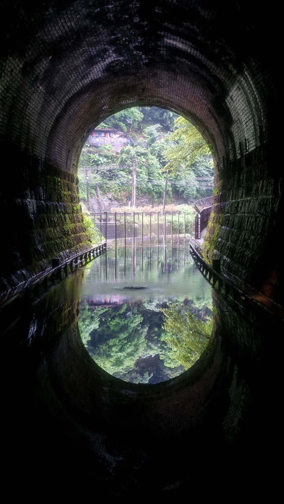
The route I chose parts from the official cycle way and joins a river valley and takes you through some pretty villages, especially Shuangxi – known for its historic old street and releasing lanterns. Roughly 5km further is the entrance to the second rail tunnel – officially called “Sandiao Ecological Friendly Tunnel” . For some reason, this one has a weird entry system where you have to register yourself for free online and show the staff a QR code. But it’s equally, if not more fun to ride and you pop out on a very quiet road along a gorgeous river valley. With the rain and mist, it actually feels more atmospheric.
I follow the quiet lanes to Houtong. From afar it looks like another unassuming town – but it’s actually pretty unique. It’s full of cats. Like many others in this region, Houtong was once a mining town but after the industrial decline cats took over and gradually became the town’s tourist attraction. Houtong is an interesting place to explore for an hour or two, even with the rain.

The final stretch follows Keelung River to Ruifang and then you have a choice. You can stay in nearby Jiufen – a very touristy but extremely picturesque lantern-lit former mining town – or Keelung, a moody and ageing harbour city best known for its night market and rain. As a first-time Taiwan visitor, I recommend staying in Jiufen. It’s a shortish climb up here from Ruifang, but watch out for the buses. As dusk sets in and the thousands of day-trippers leave Jiufen for Taipei, the lanterns light up all over town, creating that fairy tale like atmosphere Jiufen is known for. There are some tea houses that also serve dinner open late-ish, if you want to enjoy another of Jiufen’s specialties.


Day 8: Jiufen to Tamsui – Taiwan’s Northern Coast
Coastal roads, beaches & fishing towns
Distance: 88km
Elevation: ~540m
Another day of easy, coastal riding. This time with wall-to-wall sunshine.
Taiwan’s northern shores have a very different feel to the rugged east coast, but barely less picturesque. Rocky shores backed by vividly green hills interchange with fishing villages and beautiful sandy bays adorned with surfers and day trippers from the city.
Along the coast is the port city of Keelung. With its weathered tiled buildings and near-constant rain, Taiwanese often refer to Keelung as the “Rainy City”. But not today – the city reflects uncharacteristically brightly in the sun-filled calm waters of the main harbour.
One beautiful beach after another reveals itself along the route. Dawulun Beach in particular left the strongest impression and a desire to spend the rest of the day just lingering there. A little further near Wanli Beach, a handful of curious UFO-like houses make for a curious sight – covered in moss and abandoned. A project that was apparently known as the “Future House” – not sure what went wrong there.


The route follows highway 2 along the coast, but often opens up dedicated bike paths and little side roads you can hop onto for a more peaceful cruise. Going anti-clockwise here definitely helps. On paper, it’s a flat and smooth route that could be ridden quick, but there are so many places asking for a little stop or a mini detour that you may find yourself having to face some tough choices.
I opt for beachside lunch and then a little detour to Taiwan’s northernmost point, marked by a lighthouse. Either side of the cape are a cute fishing harbour and the picturesque Laomei Beach. I suggest taking another scenic detour at Linshan Cape (next to Baisha Beach), which has a scenic traffic-free section including a well-maintained boardwalk. I speed up a bit as sun approaches the horizon and after exploring some farm roads arrive at Tamsui.

It may not feel like it, but Tamsui is already part of Taipei – there’s even a metro (MRT) line that goes all the way here. Tamsui is a laid-back riverside district that certainly feels a very different pace to ‘proper’ Taipei. It’s got some very nice waterfront promenades which, facing west, are the perfect place to enjoy the sunset (with a large ice-cold bottle of Taiwan Beer in hand of course).
Day 9: Taipei Finale via Yangmingshan
Distance: 53km
Elevation: ~900m
Central Taipei is less than 30km effortless, care-free riverside path riding from Tamsui. That’s the obvious route to follow for the finale, but feeling it’s too easy – I opt for a more interesting finale via the nearby Yangmingshan National Park. The volcanic park’s proximity to Taipei makes it the local cyclists’ and hikers’ playground, with elevation of over 1,100m. One of the most iconic Yangmingshan climbs is the Balaka Highway (road 101A) and it conveniently starts in Tamsui. Unlike some of the other roads here, the Balaka is extremely quiet – and is more of a steady long ascent rather than anything painfully sharp.
The bigger part of the Balaka climb goes through pretty dense vegetation (and so there’s always some shade), before eventually opening up to rolling grasslands, and the first misty glimpse of Taipei.
The climb peaks at 840m just after the visitor center for Datun National Park. From there, take the route down south and see the majestic views of Qixing Mountain and Yangmingshan’s volcanoes, one billowing stinky steam in the air.
As I bomb down the descent, Taipei below grows out of the fog and before I know it, I’m down in the town proper. The rest of the way I follow river paths – the most guaranteed way of uninterrupted and relaxed riding in the city – meandering along the Keelung River through the capital’s northern districts before finally reaching Xinyi. Where the Taipei 101 awaits. Of course – where else would I finish!


Cycling in Taiwan FAQs
What’s the best time for bike touring Taiwan?
For me, the sweet spot months are March-April or October-November.
Summers really heat up from May to September complete with regular downpours and humidity, and also the chance of typhoons in the latter half.
Winters are actually mild especially in south, but winds tend to really pick up, while the northern and northeastern parts of Taiwan can get rainy and sometimes chilly. And if you’re heading into the mountains – you can often get snow if high enough.
That said, Taiwan’s weather is quite unpredictable especially in east/north and the mountains – so you can get rained on or unexpected headwinds at pretty much any time of the year.
Where to start and end the Taiwan cycling tour?
If you’re looking to do a route similar to this (rather than a full loop) – I’d recommend making your way to Kaohsiung then starting just south of the city, then make your way around the east coast and end in Taipei. As that’s where you’re probably going to be flying to/from. So for this you just need to take the high-speed rail from Taipei to Kaohsiung Zuoying (put your bike in a bike bag), or a slower TRA train (bike doesn’t need a bag).
Can you take bikes on trains in Taiwan?
Yes – you can, with some caveats.
For HSR (High Speed Rail) trains e.g. Taipei to Kaohsiung, you’ll need to buy a soft bike bag, take the front wheel off and voila – the bike now counts as normal luggage. So you can store it where other luggage is stored – ideally in one of the oversized luggage carriages.
For TRA (local) trains like the one from Kaohsiung to Fangliao or along the east coast, you can buy a bike ticket (50% of the human ticket cost) – either on the spot or in advance. You can just take the bike as is with you onto the carriage and sometimes there’s dedicated space.
Often you can just get the space when you turn up, but on the more popular routes like those from Hualien – it’s wise to book at least a day ahead to avoid headaches. Bike spaces are limited and TRA staff tend to stick to the rules. Oh and keep in mind that some of the smallest / most remote stations don’t allow you to get on or off with a bike, as I learned the hard way once. TRA bike-friendly train timetable can be found here.
Which direction is best for a Taiwan bike tour?
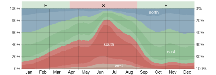
Either works, but if cycling March-September I recommend anticlockwise (south to north) for a couple reasons. Mainly that you’ll be cycling on the coast side, so better views and easier to weave in and out of coastal paths. The other is that it’s nice to end in Taipei (both as a symbolic finish but also for then not having to make your way back to Taipei where you’re probably departing from).
If going October through to February, there’s a hichance of prevailing northern wind so you may want to choose north-south instead to avoid nasty headwinds.
How long does it take to bike tour Taiwan?
A Taiwan bike tour can be planned for as little as 1 week – with this itinerary covered in 9 days averaging around 80km per day. But if you want slower pace, or completing a full loop of the island, I’d recommend 2-3 weeks to really enjoy it.
Do I need to book accommodation in advance?
Generally you can just book on the day on Agoda / Booking.com or even turn up in person, but there are exceptions:
- Remote locations like mountain passes with scarce mountain lodging should always be booked in advance. To avoid unnecessary headaches and/or descending mountains in pitch dark.
- Public holidays – always check when the major events are when Taiwan goes travelling, and if you can’t avoid those periods then definitely book ahead. This also goes for booking trains. By far the main one is Chinese New Year, but there are a few other annual festivals to look out for.
What type of bike is best for Taiwan?
A road bike. Most roads are in a very good condition and even majority of the small farm and access roads are paved. But there are hills so a lighter bike is perfect. An endurance bike or gravel bike would be a good choice, too.
Is Taiwan safe for cycling and bike touring?
Yes.
Drivers are generally respectful and aware of cyclists – with the exception of some bus drivers. Most roads have nice wide shoulders shared with mopeds, or dedicated bike paths. The only ones to watch out for are the tunnel sections of the Suhua Highway north of Hualien which I suggest to skip.
City cycling is less pleasant (mostly because of pollution and annoyingly long traffic lights) but pretty safe.
In terms of crime – if you leave your bike unlocked it’ll 99.9% still be there when you return.
Do I need to speak Mandarin?
No – but it helps to learn some key phrases.
Younger people will string some sentences together in English, whereas the older generation – often those you’ll encounter on the East Coast and in the countryside – rarely speak any. So while it’s good to have Google Translate on hand, I’d recommend learning a few key phrases to use in shops, restaurants and hotels at the very least.
While Taiwan’s official Cycling Route 1 is a fantastic introduction to the island, I think this variation offers a more rewarding mix of scenery and riding. From the beaches of Kenting and the Pacific cliffs of the east coast to the rice fields of the Rift Valley and the volcanic slopes of Yangmingshan, it showcases almost every side of Taiwan in just nine days.
If you’re looking for a Taiwan bike tour that combines coastal riding, mountains, great food and easy logistics, I’d struggle to think of many places in Asia that do it better.
» Read more: The Ultimate Guide to Exploring Taiwan
» Read more: Bicycle Touring South Korea: A Beginner’s Guide